
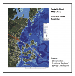
 Unexpected flooding has been a frequent topic in the news recently, forcing communities across the country to seriously consider their levels of preparedness, including zoning restrictions. This is not a new topic of discussion in Tantramar, an area of New Brunswick that is identified as a high-risk flood environment due to climate change, and high tides in the Bay of Fundy. Yesterday the CBC released news about outdated flood-risk maps, announcing that the department of environment is starting to map at-risk areas, an accomplishment already achieved in the Town of Sackville!
Video: Sackville Updates Flood Map
Article: Scientists warn about outdated flood-risk maps